Saturday, October 22, 2016
Valentia Island
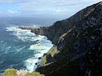
From Portmagee and the bridge, Valentia Island looks like a long gentle ridge a few miles long. When you get to the crest of the ridge, you sort of realize that the north side of the ridge isn't so gentle and that it's a long way down to the ocean.
We began with a stop at the Skelligs Experience Visitor Center, which gave us a chance to experience Skellig Michael in the absence of actually being able to visit it. From there, we headed up to Geokaun Mountain, the highest point on the island (Geokaun sounds to me like a Scandinavian adventure sport or the name of a german SUV).
It's privately owned and you have to pay a small fee, but it was worth it. The short trail out to the Fogher Cliffs offered great views of the western end of the island and you could almost see Newfoundland in the distance (Valentia Island was the taking off point for the first transatlantic telegraph cable back around 1860). You could see a little bit of the Dingle Peninsula to the north and from the top of Geokaun you get great views east toward the rest of the Iveragh Peninsula.
Labels:
ireland
Location:
Kerry, Co. Kerry, Ireland
Subscribe to:
Post Comments (Atom)


No comments:
Post a Comment