
This was the first time in a long time that M & I could get away together and we decided to head up to the Skagit to see the Tulips. My ideal tulip trip would be to run into them unexpected in the middle of nowhere with no one else around and this morning in Seattle, I had visions of gridlocked farm roads, overpriced parking, tour buses, crowds of gawkers, and low-flying helicopters. I guess all of those things were there, but somehow we managed to avoid most of it, and I came away reminded that just because something is overhyped and commercialized, it can still be a lot of fun!

The weather was great. The timing was perfect, with most of the fields in full bloom. The photography was both helped and hindered by the slight haze, and the photos themselves suggest that my camera does some weird stuff with bright, contrasty colors.

We ended up at Seeds in La Conner for lunch - which was good, but took about 40 minutes longer to arrive than it should have. Blame it on the crowds.

 Saturday morning I loaded up the boat, grabbed coffee, and headed for the Edmonds ferry. Over the next few hours the almost-clear skies gradually disappeared - just the opposite of the forecaster's pronouncements.
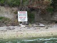
 I took the kayak up to Fort Flagler and spent several hours paddling around northern Kilisut Harbor - the narrow inlet between Marrowstone and Indian Islands. I went south, taking a break at Mystery Bay, before crossing over and heading back north along the wonderfully undeveloped shoreline of Indian Island. One advantage of the Navy storing bombs there is that security is tight and opportunities for waterfront real estate and mega-mansions are nil. I kept expecting guards to drive down to the beach to make sure I didn't land, but if they were watching, they didn't show themselves. A lone coyote watched me from the top of a bluff for five minutes as I paddled by. A seal popped up at some point and bald eagles occasionally flew over - but that was it.


