Sunday, May 22, 2011
Blaine Stairs
I've discovered that climbing stairs wears me out without wearing out my knees and the last two months I've been visiting the Blaine stairs regularly. There are almost 300 steps between Lakeview and 10th East, distributed among 13 flights over a span of two blocks. If you chose to walk up from Lake Union through the Colonnade (the forest of concrete piles now turned into a mountain bike park) under I-5 and then from 10th East on up to Volunteer Park, you could get quite a bit more vertical.
The stairs provide great views of Lake Union, the Space Needle, Queen Anne Hill, and the Olympics. I can even get glimpses of the Sound. The Streissguth Garden makes the last three flights above Broadway East a little easier. And as a geologist, I can't help but think about the implications of urban landslides as I climb the stairs, noting the tilted stairs and the complexly terraced slope.
The Beyerlein's Public Stairs site
Susan Ott Ralph's Seattle Stairs site
Monday, May 09, 2011
Craft Island
We celebrated Mother's Day for Michele, Jane, and Alison this year with waffles from our almost-re-done kitchen. And then, despite ambiguous weather, decided to head up to the Skagit Delta where we met up with J&R and their family for the short walk out to Craft Island (Little Island?). It's only a little more than an hour north in the car, then a half-mile walk out through the marsh to this rocky bump in the middle of the flats. The weather was gray and cool - sun would have been nice - but what a neat place.
Sunday, May 01, 2011
Cumberland Plateau
I think my main purpose for coming on this trip was to help D negotiate the three flights (four airplanes and four takeoffs, but only the three with working landing gear actually count) and to hand him enough cash for three days of pizza.
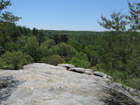
But that gives me time to explore. Saturday I left early and headed east to spend the day looking for waterfalls and natural bridges and rocky bluffs. The bridges and arches are a great contrast to the ones I know better on the Colorado Plateau - they're all sandstone, but in the southwest, they're easier to find. Here, you walk through the forest until you notice that the shadow is actually a 100' arch of rock passing through the canopy above your head!
I checked out the Big South Fork (of the Cumberland River) - including Twin Arches (interesting to contrast to yesterday's Double Arch bridge on the Natchez Trace), Leatherwood Ford, and the high bridge at Rugby. And then drove south to the Clear Fork and the Obed River before driving back to Nashville and Opryland, arriving somewhere in the middle of Round Five.
Natchez Trace
Last Friday, I was driving the Coulees of the Columbia Basin, this Friday I'm exploring central Tennessee . American Airlines delivered us to Nashville late this morning - after an unplanned overnight in Dallas - and I managed to get D to Opryland half an hour before Round One started. I checked in, then hit the road. I drove south an hour or so on the Interstate and then cut over past the Saturn factory to pick up the Natchez Trace Parkway for the drive back to Nashville.
The Parkway is one of those wonderful winding two lane, protected corridor highways that makes you realize that roads can be beautiful. Sure the setting helps, but it's mainly about landscape planning and highway design. This one runs 400+ miles from Natchez to Nashville - following the route of the original overland route from the lower Mississippi into the interior on the back side of the Appalachians. Remnants of the original road can still be seen, abandoned when steamboats began running up the Ohio and the Cumberland rivers.
There were few people on the road this perfect spring afternoon. I checked out waterfalls and the great double arch bridge near the north end. And then waited an hour for a table at the Loveless Cafe, where I had ham and biscuits and a Nashville beer.
Subscribe to:
Posts (Atom)