Wednesday, November 22, 2017

Jerimoth Hill


Rhode Island's highest point is not a terribly difficult climb. The route finding is easy, the distance is minimal, and the elevation gain unremarkable. The view from the summit is ... blocked by the trees.

Jerimoth Hill, all 812' of it, is in western Rhode Island, not far from the Connecticut state line. State Route 101 crosses the hill near the summit, so the final leg is an almost level trail not more than a few hundred yards long. The summit is marked by steel ammo canister - I didn't add my name.  Nearby are some storage sheds and what I assumed were telescope mounts - Brown maintains the site as a potential observatory.

Until recently, this was one of the more difficult high points to reach, as the the owners of the adjacent land weren't keen on visitors, but now the summit is marked on the highway and the trail is open to all. There are residences nearby, visible through the woods.

For other state high points, some perhaps more familiar, or at least a bit more dramatic, check out hshipman: highpoint.


Westerly


The south shore of Rhode Island was really cold. On Friday, there were gale force winds from the north, making the low 30s feel a lot colder. On Saturday morning, the winds had dropped, but so had the temperatures. The thermometer in my rented Camry said low 20s. So much for iPhone battery life!

I hit most of the beaches - or so it seemed - between Narragansett and Westerly on Friday. I walked down the narrow lane to the Watch Hill Lighthouse, then practically ran (to keep warm?) back through town and out to the dunes looking over Napatree Point to catch the setting sun.

I've wanted to see Napatree ever since I read R.A. Scotti's account of the 1938 hurricane in Sudden Sea. The storm pretty much washed away everything on the spit, along with much of the spit itself (I may post more on the other blog).

I spent Friday night in a La Quinta just over the Connecticut line, but drove back down to the beach on Saturday morning to watch the sunrise over the Atlantic - and to get another look at Taylor Swift's little beach cottage, perched on Watch Hill. I found the grand Ocean House hotel a much more interesting looking place. I considered seeing if they served breakfast - to riff raff in blue jeans - but decided I had too much still to do before I had to return my car to the Providence airport at noon.

I settled for coffee at Junk & Java, which was clearly where everyone else in western Rhode Island was settling for coffee that morning, too.


Conanicut Island


My first stop on Friday morning -- after coffee (and a doughnut?) at the hotel, a bus ride to the airport, and picking up my rental car -- was Beavertail Point at the southern tip of Conanicut Island, at the entrance to Narragansett Bay. It's a very old lighthouse (and the site of even older ones) on a rocky point extended out into the Atlantic.

I drove out to Fort Getty, but really didn't explore -- I had an ambitious schedule for the day. And checked out the shore in Jamestown, the largest town on the island, which faces east across the bay towards the bridge and Newport.

And then it was off to Narragansett and a series of beaches farther east. It was chilly. I may come back to that.


College Hill


College Hill is just east of downtown Providence, on the other side of the river. It's a pleasant walk from the convention center and I got there both early one morning and for lunch on another day. It's a historic neighborhood, with very nice old homes, old churches, and the very different campuses of Brown University (traditional New England quads) and the Rhode Island School of Design (more urban, street facing).

My morning walk provided a strong sense of deja vu, since I'd done a very similar walk on a very similar day during my very similar visit nine years ago. But not everything was the same. This time I checked out the RISD Museum Store (I didn't have time for the Museum itself) and their bookstore (lots of art supplies, no surprise).

This trip I ran across a very large blue teddy bear with a desk lamp on its head on the Brown Campus - definitely not there in 2008. I also found Dave's Coffee on South Main Street, which I did not recall from my previous trip. I found another Dave's Coffee a few days later off Post Road (US 1) west of Charlestown.


Providence


Downtown Providence seemed much as I remembered it from 2008, my last trip here for a meeting (Providence: October 2018). Most of my four+ days were occupied by the CERF Conference, but I was able to fit in some walks around town and since this isn't as social an event for me as some, I had some evenings on my own.

I was staying at the Dean Hotel, barely a block from the convention center. Apparently, until relatively recently this place had a somewhat more colorful reputation - it wasn't lattes and doughnuts being sold in the lobby (or upstairs, either). The room was small and spare (as was the small cage elevator), but it was pleasant and convenient. Bolt Coffee, in the lobby, served 49th Parallel Coffee (from Vancouver BC).


It was hard to avoid Knead Doughnuts. They were on the counter at Bolt downstairs. They were available in piles at the breaks during the meeting. And they were spread out in neat rows at the main shop on Custom House Street. I'd like to point out that I think I only ate four over the four days I was in Providence, but having just gone back and looked at their website, I'm sort of wishing I had one right now.


Tuesday, November 21, 2017

Touro Synagogue


I had headed to Newport to explore its coastline, but accidental discoveries are what make travel fun. I found coffee and lunch downtown and was wandering past the synagogue (which I had only learned of the night before) when I heard a tour guide mention to someone else that there was still room on the last tour of the afternoon.

The synagogue was conceived in the mid-1700s by Jews that had left the Caribbean for the religious tolerance of the Rhode Island Colony. It was built in 1763, which makes it the oldest synagogue in the United States. The building survived the Revolution (as a British Hospital), but its members scattered after the war, and it wasn't until later in the 19th century that a new congregation began worshipping there again.

Touro Synagogue has become a symbol of religious tolerance in the United States. In 1790, in response to concerns about how religious minorities might be treated under the newly formed American government, George Washington wrote a powerful letter to local Jews condemning bigotry and persecution and underscoring the government's support for all citizens (letter). Interesting historic perspective - this is prior to the ratification of the Bill of Rights - but clearly this issue was on the mind of President Washington.

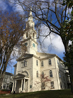
I was intrigued by the colonial architectural influences - it felt like a New England town hall, but with a bimah in the center, a lot of candles, and a deerskin Torah.


Sunday, November 19, 2017

Newport


Even on a gray weekend in November, Newport can seem like a zoo. Grabbing a parking place right in front of Empire Tea and Coffee, after circling downtown several times, wasn't the only highlight of the day, but it did seem like a bit of a coup.

The Cliff Walk extends from Easton's Beach at the north all the way south and around the corner at Lands End, passing Salve Regina University (Catholic), The Breakers (Vanderbilts), Rosecliff (paid with silver from Nevada's Comstock Lode), and Rough Point (more Vanderbilts), and few dozen other monuments to wealth, inheritance, and aristocracy.

Ocean Drive extends along the southwest shore of Newport. I admit that I didn't find the boxy stone chateaus along the Cliff Walk and Bellevue Drive very compelling, but I really liked the shingled New England "cottages" on Ocean Drive. The houses were more interesting and more colorful and they complemented the landscape better (unfortunately, I didn't end up with any pictures of this stretch).

Brenton Point, at the far end of the loop, is the site of a large memorial to Portuguese navigators and a smaller one to fishermen lost to the sea. It looked like it would be a pretty brutal place during a big winter storm.


Monday, October 30, 2017

Jordan Bridge


This was my first long ride since my aborted attempt to circumnavigate Lake Washington back in mid-September. And what a nice day for it. I parked at Twin Rivers Park in Arlington and did a 30-mile loop - down the Centennial Trail (up, slightly, actually), east across Getchell Road to Granite Falls, and then north on Jordan Road, which follows the northeast side of the South Fork of the Stillaguamish (although it is usually out of site).

I stopped briefly to walk across the Jordan Bridge (pedestrians and bikes are fine, cars must take the long way around). The sky was blue, the leaves were yellow, and my legs were pretty sore, but I guess that's one of the points of forcing myself outside on these nice days!

Seattle


This blog is about places - or at least is place-based. So not much seems to happen when I'm not going to new (or interesting) places. Occasionally, glimpses of more routine stuff creeps in, but even then, it only happens when I have photos that I like.  I dabble with photo journals of the places we eat, the places I drink coffee (Emerald City Coffee), and even the covers of books I read, but those are simply records of events - not excuses to develop content (whether substantive or not).

The previous entry was from Boise, on the last morning of our trip. A week later (mid-September), 35 miles into a ride around Lake Washington, I tried to see what would happen if I turned the front wheel sharply while at the same time hitting a large speed bump in the road. What happens, apparently, is that it pretty much rules out bike rides or late September hikes in the mountains. Time on the computer is spent shopping for new bike helmets and paying radiologists rather than posting pictures of places I didn't get to.

But I digress. Last week - now late October and fully recovered from my experiment in middle-aged ballistics - I spent four days at the Geological Society Meeting meeting in Seattle. The weather was wonderful and I took advantage of it by walking down to the Market a couple of times for lunch. I love the new "front porch" which looks out over the sound and anticipates the rapidly approaching absence of the viaduct. I also love Storyville Coffee's location above the market. Like so much of Seattle's food scene, it's all about presentation and an excess of disposable income, but I'm a sucker for aesthetics and sun shining in through large semicircular windows. It makes $10 for a latte and a cookie almost make sense!

I don't get to hang out with geologists much in my job, so the meeting was a lot of fun. I enjoy my regular company of ecologists and land use planners, but they just don't share the geologist's appreciation for geographic jig saw puzzles and their twisted sense of long periods of time.

I went to talks on Puget Sound earthquakes, BC landslides, Lake Michigan bluffs, Martian shorelines, and of course, the giant floods on the Columbia Plateau. I learned how the volcanic record of the Pacific Northwest records the post-subduction history (50M years) of the remnants of the subducted Farallon Plate. I heard about the history of hydraulic fracturing in petroleum production and about advances in multispectral remote sensing. Maybe the coolest talk was the description of the Hell's Creek formation in North Dakota, where the Cretaceous-Tertiary boundary is recorded as a jumbled layer of rocks and dead fish fossils, some of which still have tektites (small spherical stones generated by the heat and pressure of the impact) in their gills.

Sunday, September 24, 2017

Boise


Boise was the last stop - or at least the last night - of our road trip. We've heard that Boise is a neat small city to explore, but this visit was pretty short. We checked into a nice, but generic, hotel out near the Interstate, and headed to Luciano's for dinner (which was good). We drove a little bit around downtown and Boise State.

The next morning, I drove back down to the river with my bike and rode up and downstream on the nice system of bike paths. Just like all the other early morning rides on this trip, it was an awfully pleasant way to get some exercise.

Downstream from Boise itself, Garden City seems to be positioning itself as a destination for recreation and entertainment along the river, although it looks much of that may still be in the future. The highlight on this early Sunday morning was the line up of guys with surf boards waiting to take their turn surfing the standing wave below the small dam! Only a couple that I saw were even able to get up - most washed out as soon as they tried to enter the treadmill.

From here, it's just a long 500-mile day from Seattle - we pulled up to the house around 5:30. This is the final post from "Road Trip 2017," unless I decide to pull together some sort of summary (25 blog posts, 21 days, 6200 miles, 10 bike rides, and so forth).

Shoshone Falls

Five years ago, I paddled up to the base of Shoshone Falls in a kayak (hshipman: June 2012). But I never got up to the viewpoint to see them from above. This trip offered the chance to do that and I thought M find them sort of neat, too. Flows were incredibly low, even lower than my earlier visit, and a trickle compared to full flood conditions.

Shoshone Falls is a little over 200' high - more than Niagara -- although even at high flow it can't really compare in volume. But in terms of some combination of height and volume, it must be among the largest in the American West.  Celilo Falls on the Columbia (now drowned behind the Dalles Dam) had huge flows, but was no where near as high. The Great Falls of the Missouri may have been impressive, but weren't of this scale. Willamette Falls near Portland and Kootenai Falls in Montana are larger in terms of average volume, but again, not as high. The kayaks below the falls provide some sense of scale.